Walking the Yorkshire Wolds Way
We undertake a hike along the Yorkshire Wolds Way, a fabulous trail in Northern England.
Walking the Yorkshire Wolds Way
https://www.contours.co.uk/walking-the-yorkshire-wolds-way
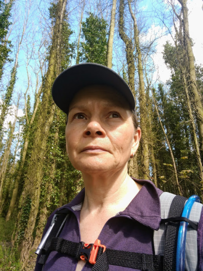
by Christine Saul
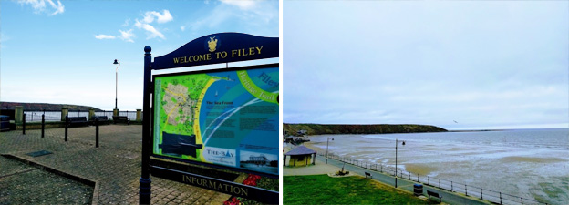
The Yorkshire Wolds Way National Trail has been on my ‘to do’ list since completing the Cleveland Way back in September 2013. The two walking holidays in Yorkshire meet/join at Filey, so it seemed an obvious choice to continue on from the Cleveland Way and head south along the Yorkshire Wolds Way from Filey to Hessle and the Humber Bridge.
Walking the Yorkshire Wolds Way from Filey to Hessle actually goes in the reverse direction recommended by National Trails, although they do admit the trail can be walked in either direction. I chose to walk in reverse so I felt like I was on one continuous journey north to south for both trails, but I would recommend walking it from south to north as per National Trails' advice. I was walking into the wind a lot of the time, and if it had been sunny, I would have also been walking into the sun. National Trails recommend walking south to north so that you have the sun to your back and also because the beauty of the scenery intensifies by the day heading northwards. I was once again blessed with good weather for my 5 day walk; well, good for late March anyway!
The first highlight of my holiday came whilst driving to Hull; I saw the Red Arrows take off from RAF Scampton as I drove past, then fly back again in formation, five planes in total. I arrived in Filey just after 12:30 and walked down from the train station to Filey Sands. I didn’t walk all the way to Filey Brigg, the official start, as I had walked this section into Filey when completing the Cleveland Way back in 2013.
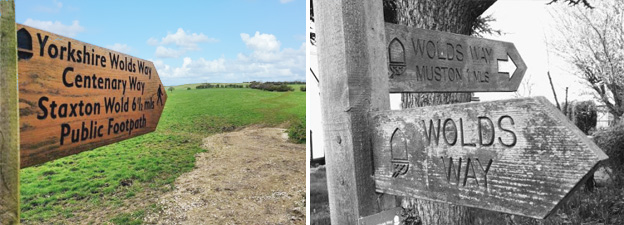
It was a grey old day, cloudy and overcast and a bit chilly, but dry. Following the main road out of Filey the trail eventually left Filey behind, crossing fields towards Musten. Quite a few new gates had been installed in the fields, all marked with the National Trail acorn symbol; most of them however just stood on their own in the middle of nowhere, serving no purpose. I’m guessing they get connected by electric fencing during the summer months as there was evidence of old temporary electric fencing in places. Musten was a pretty little village in full spring-bulb bloom. From Musten the trail followed field edges to Folkton Wold and into Stocking Dale, a small wooded dale before opening out into Camp Dale. The trail runs on a joint route with the Centenary Way, contoured around the edges of Camp Dale rather than going through the bottom of the dale.
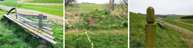
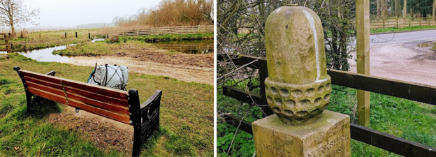
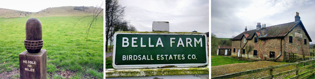
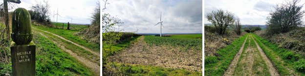
I passed the first of a large carved Acorn Mile Post. It informed me I had walked 7 miles from Filey and had 70 miles to go to Hessle (something not quite right with the calculations there as the trail is supposed to be 79 miles!) These large carved Acorns appear at 5 mile intervals along the trail. There was also a shaped National Trail bench next to this Acorn. The trail continued across Flixton Wold, up and down several times through more fields before a short, very steep descent to a sunken path, which turned into a farm track and eventually a tarmac lane up to Staxton Wold and past RAF Staxton Radar Station. After about a mile along a lane, past a very smelly pig farm, it was back to walking along field edges, heading steadily downhill towards Ganton, past another large carved Acorn; 12 miles it said from Filey, 65 to go to Hessle. Just under half a mile later I reached the small village of Ganton, today’s destination. I left the trail to head for the village pub, the Ganton Greyhound, an old coaching inn with typical pub accommodation and good food, I chose home-cooked shepherd's pie and veg, and sat by the very welcoming real fires.
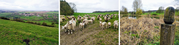
After a good cooked breakfast to fuel me for the day, I set off walking from Ganton at 8:45. It was another overcast but dry day with very low cloud/fog/sea fret, even though I was high up a lot of the time walking along the tops of the Wolds I had no good views today. It was a much more varied walk today; I enjoyed it much more than yesterday, even without the views. Yesterday was a lot of walking along arable field edges, and apart from the large Acorns there was not much interest or variety in terrain; today was much more interesting terrain. Field paths still remained, but there were also nicer, wider, green lane-style field paths, with not so many narrow arable field edges, plus quite a few woodland sections and farm tracks. The hedge blossom was out down one lane and there were lots of pheasants, hares and rabbits to be seen along the way - one field had a group of four hares all hanging out on the husp/brow of the field. There were plenty of farm animals too today, including sheep with their very tiny lambs, cows and their very small calves, horses, geese and another smelly pig farm! The pigs always sound awful; they don’t have a nice bleating or mooing sound like sheep and cows, just awful squawking - they sound like they’re being tortured!
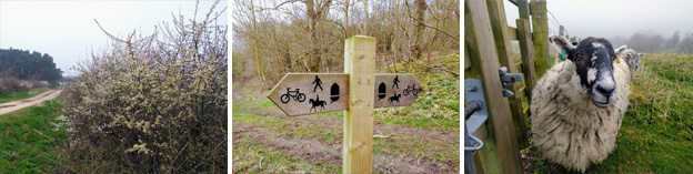
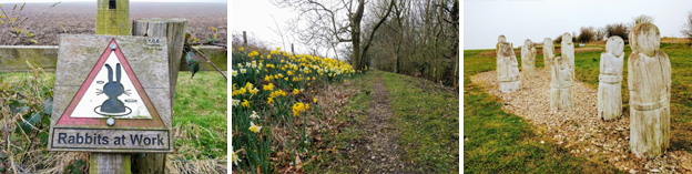
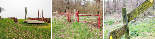
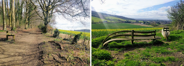
Just past Sherburn the trail ascended gently up onto the Wolds, then contouring on a fairly level path along the ridge above East Heslerton, where I passed another Acorn milepost, 60 miles to Hessle. On a good day there are great views across the Vale of Pickering and possibly even views of the North Sea apparently; not today though, there were maybe views of two or three fields ahead only. I passed a bunch of five very friendly sheep who all came running towards me, though I thought they were going to run straight past me as most sheep would, but these ladies stopped at my feet. I’m not sure what they were expecting from me? Here I also passed another shaped bench engraved with poetry. After crossing a small lane and a ‘rabbits at work’ warning sign - first time I’d seen one of these signs on a walk - the trail continued by the side of fields towards West Heslerton Brow and past lots of rabbit holes - you definitely wouldn’t want to twist your ankle in one of them, so the sign was very relevant. On entering the edge of Knapton Plantation the path was abundant with daffodils for a short section into the woods, and were very pretty indeed. The trail continued through the wood, a lovely contrast to the fields, before exiting briefly out into the open and walking along old raised Earthworks to emerge at the ‘Enclosure Rites' art installation, part of the Yorkshire Wolds Way ‘Wander' art project. There were carved ‘guardians’ which refer to mysterious carved chalk figures often found discarded in old iron age settlements in East Yorkshire. Lots of red posts made reference to old burial mounds or barrows, plus there was a new dew pond. There was also a lovely rickety red gate installed as an entrance/exit to Deep Dale Plantation. On entering I saw why it’s called Deep Dale, there was a short but extremely steep descent to Deep Dale. The National Trail officer obviously had a sense of humour, as the signpost at the bottom also pointed steeply upwards!
A forest track led down to the small village of Winteringham, past another Acorn marker, the back of Winteringham church and a large ribbon tied tree. I stopped for a short snack break on a bench by Winteringham’s recently created pond and beck. It was a bit chilly to stay too long. From Winteringham it was about 3 miles to my destination today at North Grimston, and from Winteringham the trail also turned direction, now heading south. Up until now I’d been walking inland from Filey in a westerly direction. Now mainly following farm tracks, it was a gradual ascent to another plantation, before following a farm track all the way to North Grimston, leaving the Yorkshire Wolds Way for the last mile just past a lovely old farmhouse, Wood House Farm. I arrived at my destination, The Middleton Arms just after 2:30. It wasn’t busy and there were two big black labs sprawled out asleep in the bar area, one on a sofa and the other much older one on the floor, who welcomed a bit of a fuss. The sun had just started coming out as I arrived so I got a drink and sat outside in the sun for a while before settling in my room. Another typical country pub, a friendly landlady, lovely bar and lounge/restaurant area, and the rooms were comfy and clean. There was a real fire again in the evening which i sat in front of and enjoyed a lovely evening meal - ricotta and spinach stuffed pasta with garlic bread and salad.
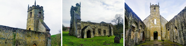
It was a damp, spitty day today; it rained overnight and stayed overcast and damp for most of the day, with on and off very light rain showers - visibility was better though today. I left north Grimston at 8:40. I had a big mileage day today, and retraced my steps the mile back up the lane to rejoin the Yorkshire Wolds Way. Not long after rejoining the downhill trail to a beck I passed my first Acorn for today, 50 miles to Hessle. Then uphill again, my first village destination today was Wharram le Street. Just past here i passed a farm called Bella Farm; Bella is the name of my beloved dog so i took a photo! The first highlight of today was Wharram Percy, the most famous example in England of a deserted medieval village settlement maintained by English Heritage. The only visible remains are of an 18th century ‘improvement farm’ and 12th century St Martins church. The sky cleared briefly for some dramatic church photos.
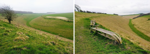
From Wharram Percy the trail climbed gradually above Deep Dale, another one, following fields and farmers busy ploughing along a green lane. I passed the 45 mile to Hessle Acorn and the highest point, 213m, on the Yorkshire Wolds Way. Eventually turning off, the trail descended to Vessey Pasture Dale and then ascended straight up again on the opposite side. A common theme today; lots of short, steep ascents and descents between dales. The trail descended down a track to the small village of Thixendale, a single lane of houses hidden in the dale. Leaving the village by road initially, the trail turned off and into Thixen Dale, a lovely dale with uncultivated steep, yellow, grassy banks each side and a green grass carpet floor. This was the type of dale I was expecting to walk through a lot more of along the trail; today there were a few, which was another highlight of the day.

At the end of Thixen Dale the trail took a sharp turn almost back on yourself ascending out of the Dale. Here, maybe because i was walking the trail in reverse, I missed another Wander Artwork, a swirling pattern cut into the landscape, though it wasn’t obvious like the previous artwork. Across a few more fields the trail went down and up again through West Dale, past Acorn 40 miles to Hessle and down to Fridaythorpe. Fridaythopre wasn’t an attractive village, the pub was closed and up for sale but there was a cafe where I stopped for lunch, Seaways Cafe, just off the trail in the village on the B1251. This was a proper cafe serving a typical walker, cyclist and biker menu and huge mugs of tea, lovely. Fridaythorpe is the halfway point on the Yorkshire Wolds Way. After lunch it was about another 8/9 miles to go, down into Holm Dale - another lovely grassy dale - and eventually up and out of Horse Dale, past another couple of shaped poetry benches and through fields again towards Huggate. Turning off just before Huggate, the trail followed a farm lane for a while, past Acorn 35 miles to go, before turning off and contouring around Huggate Sheepwalk, above Pasture Dale. Down again steeply to Nettle Dale and steep up immediately along Cow Moor, before the last down on the trail today, this time zigzaged so it was not so steep, and past some flowering yellow gorse before ascending again above Sylvan Dale. Half a kilometre further and it was time to leave the Wolds Way and head down on the Minster Way to Millington. I arrived at Laburnum Cottage B&B at 5pm, my home for the night. A very comfortable 3* b&b, with a nice large bath to soak my aching legs after a long day. I had dinner at the local pub, the Gait Inn, and enjoyed homemade lasagne and salad.
The weather looked a bit more promising to start with today - a bit brighter than the previous three days - it was still mainly cloudy though and not long after setting off it did rain lightly for about half an hour. After that it was mainly cloudy again but with a few sunny spells.
I set off just before 9 and retraced my steps back up along the Minster Way from Millington to rejoin the Wolds Way, I think this section to rejoin the trail was the longest ascent on the whole trail, not the steepest though. Once back on top of the Wolds there were good views back down to Millington and across the Vale of Yorkshire. The trail today was mainly along green field edges or small farm lanes, plus it went through at least three farmyards. Not too long after Millington I passed the 30 miles to Hessle Acorn, which was a bit worse for wear, the Acorns on the south of the trail are older than the northern ones and most of them have streaks of bird droppings down them! Just past Nunburnholme and before Partridge Hall, one field of sheep and lambs could hear the farmer coming on his quad bike, so they all ran to the gate just as I was going past, and the farmer was bringing lots more sheep and lambs to join them; it was quite noisy with all the bleating excitement of new friends joining. After here it was a mile road walk down a quiet lane towards Londesborough, past a information sign depicting points of interest that can be seen across the Vale of York and a green bench with the national trail Acorn logo.
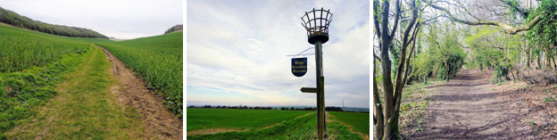
The trail passed through the pretty estate village of Londesborough and across park land down to Londesborough Lake. Here was the 25 mile to go Acorn. From Londesborough there are two trail options, via the bigger town of Market Weighton with plenty of choice of shops, facilities etc. or the main trail option which I chose via Goodmanham with few facilities. I did notice a new cafe but it only opens Friday to Sunday, which was no good for me on a Thursday. From Goodmanham the trail continued along field edges to Arras Wold, eventually joining a long straight green lane, which is also a cycle route. It was very windy up on Arras Wold before being protected by hedges either side of the green lane. There was also a largish wind farm - a very appropriate spot. The large wind turbines looked quite dramatic against the cloudy skies. On the green lane I also passed the 19.5 miles to Hessle Acorn - I don’t know what happened to even mileages and markers every 5 miles! Leaving the green lane over Newbald Wold it wasn't too far to North Newbald and my destination today. It was about a mile off the trail again to walk down the road to the Gnu Inn in North Newbald. A lovely pub, I arrived quite early at 2:40 and a friendly barman showed me straight to my room. It was nice to have a lazy afternoon! They served good pub food, and Hunters chicken was my choice for tonight.
After a lovely cooked breakfast to fuel me for my last day of walking, I left the Gnu Inn at 8:50 and retraced my steps the mile back to the trail. After an initial light rain shower the weather turned out lovely, though a bit windy, but with sunny spells for my last day. It was another contrasting day terrain-wise through dales and lots of wooded sections, which was a lovely contrast to fields and farmland, ending with a three mile walk along the Humber Estuary. The first mile section was through Swin Dale, an arable dale initially with the trail walking on a wide track through fields of Rapeseed, which in a couple of weeks time will be seas of yellow, then into a lovely grassy dale. It was then up and over through fields, past the 15 miles to go marker, to East Dale/Hunsley Dale and past High Hunsley Beacon, erected in 2002 for the Queen's Golden Jubilee. It was a lovely woodland path through East Dale, Hunsley Dale and Weedley Dale. It was back into the open fields briefly before walking through Little Wold Plantation heading towards South Cave and passing another couple of National Trail poetry benches with lovely views across fields of rape, just starting to flower in the sunshine, to the Humber.
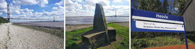
The trail skirted past the edge of South Cave heading towards Brantingham, again through a mix of fields and woodland. High up on Ellerker North Wold I got my first views of the Humber Estuary. The trail again skirted the edge of Brantingham village and headed up a lane which turned into muddy bridleway alongside Long Plantation. I passed the 10 miles to Hessle, 69 miles from Filey Acorn - they had the correct mileage total on this acorn! The trail continued down through Welton Dale to The pretty village of Welton, going up again out of Welton to Bow Plantation. Here was my first glimpse of the Humber Bridge in the distance, my final destination, still about 6 miles away. The countdown to the finish was on, as I passed the 5 mile to go Acorn in woods near a Scout Group Camp/Headquarters, crossed the busy A63 trunk road at North Ferriby, with 4 miles to go, and one more mile through woods before reaching the Humber Estuary in beautiful sunshine.

The first of the three mile section along the estuary required a low tide to walk along the foreshore, which it was, luckily for me, otherwise it would have been a detour back inland around a few roads. The muddy estuary looked lovely and beach-like in the sunshine. I went down the steps and walked the half mile section along the pebbly foreshore before going back up steps onto a path along the top of the estuary, which joined the Trans Pennine Trail for the last 2.5 miles to the Humber Bridge. I passed some old blue ‘Wolds Way’ signs; the trail used to be called the Wolds Way and changed to be called the Yorkshire Wolds Way in 2003. The Humber Bridge got closer and closer and bigger and bigger, and it was a lovely day to take photos of it. Soon after walking under the impressive Bridge I reached the stone Wolds Way sculpture which marked the end (or start) of the trail. I finished with 10 minutes to spare to walk to Hessle station, which also had a sign saying the start of the Yorkshire Wolds Way National Trail, to catch my train home.
 The Yorkshire Wolds Way was a lovely walk through the rolling hills of the peaceful Yorkshire Wolds. I’d highly recommend it; it’s a leisurely trail for more experienced walkers, but it is also ideal for people not so experienced at walking long trails. It's not too difficult or challenging, apart from a few short steep ascents and descents, and has lots of long, easy sections and it is very well way marked.
Contours Holidays pride ourselves on our expert knowledge of the UK’s trails. We regularly set out to check our routes and directions and to make improvements on the holidays we offer. You can find several write-ups of staff expeditions in our Trail Diaries.

Cross the Yorkshire countryside from the foot of the Humber Bridge to the crumbling cliffs of Filey.
Visit Yorkshire pubs for a well-earned taste of local ale, including the Wold Top Brewery, which sits on the trail near Hunmanby.
Catch a glimpse of the looming North York Moors over the Vale of Pickering.
.png)
| Code | Tour | Duration | Price per person | |
|---|---|---|---|---|
| YWW1 | From Hessle(L) to Filey | 5 days walking | £837 | |
| YWW2 | From Hessle(L) to Filey | 6 days walking | £975 | |
| YWW3 | From Hessle(L) to Filey | 7 days walking | £1109 | |
| YWW4 | From Hessle(L) to Filey | 8 days walking | £1247 |


