Walking the Somerset Coast Path
Contours Walking Holidays
Walking the Somerset Coast Path
https://www.contours.co.uk/walking-the-somerset-coast-path
by Richard Jones
I start my journey along the Somerset Coast Path on an October day in front of Weston-super-Mare’s Grand Pier.
The route heads south along the promenade, before dropping onto the golden sands of Weston Bay. Weston is known for having one of the highest tidal ranges in the world, and today the water’s edge seems a long way away.
At the far end of the beach, the Brean Down Way begins at the marina, passing beneath the impressive Old Church of St Nicholas high up on a cliff, and through the peaceful Bleadon Levels Nature Reserve. The Brean Down Way was opened in 2017 and utilises the old sluice bridge to cross the River Axe, where the ‘Great Bird Screen of Brean’ has been constructed to resemble driftwood.
I soon reach Brean, where a passageway through the sand dunes takes me onto the beach. To my right, around a mile and a half up the beach, the Brean Down rises up steeply, reaching out into the sea, and I make my way towards it.
.jpg) National Trust-managed Brean Down rises to almost 100m above sea level, with a steep climb up a series of steps required to reach the summit. I tackle these, feeling the burn in my calves, and continue along the ridge at the top to reach the 97m summit, rewarded with wonderful views down the coast and out into the Bristol Channel, across to the islands of Steep Holm and Flat Holm and Cardiff in the distance.
National Trust-managed Brean Down rises to almost 100m above sea level, with a steep climb up a series of steps required to reach the summit. I tackle these, feeling the burn in my calves, and continue along the ridge at the top to reach the 97m summit, rewarded with wonderful views down the coast and out into the Bristol Channel, across to the islands of Steep Holm and Flat Holm and Cardiff in the distance.
At the far end of the Down, the path descends spectacularly towards the old military fort, which can be explored if open. The National Trust staff are on hand during my visit and have left out torches for guests to explore the underground rooms and artillery storage.
The fort was originally constructed as a defence against the potential of French invasion in the 1800s, but with the invasion never happening, the site became a café and place of leisure and relaxation… until the outbreak of World War II, when the army returned and the site was used to develop weapons.
.jpg) The route back takes me along the old Military Road, giving an easier stroll on the north side of the Down, keeping an eye out for the wildlife that inhabits this area, before returning to pay a visit to one of the cafés.
The route back takes me along the old Military Road, giving an easier stroll on the north side of the Down, keeping an eye out for the wildlife that inhabits this area, before returning to pay a visit to one of the cafés.
From here, I drop down onto the beach. With the tide well out and the sun shining, I have a glorious walk along the peaceful Berrow Sands, passing sand dunes as I make my way towards Burnham-on-Sea. Rounding the corner, a building on stilts comes into view: white with a red stripe down its front. The building is the Low Lighthouse, in place because the original lighthouse was built with too low a vantage point for the huge tidal range, and it is still operational today.
I climb the steps up onto the promenade at Burnham, passing Britain’s shortest pier and the lifeboat station. At the far end of the promenade, I descend down to walk beside the sea wall, rounding the corner next to the tall, curved structure, and then head alongside the River Brue towards Highbridge, with the wildlife centre on the left.
Before reaching Highbridge, the path passes along a narrow path behind some houses and an industrial unit, before I emerge at the New Clyce Bridge. On the other side of the bridge begins the River Parrett, opposite Stert Point, glistening as it juts out into the water amongst sandbanks rising out of the low tide.
I hadn’t factored in just how beautiful and relaxing this section would be, with the tranquillity broken only by the wide variety of birdlife inhabiting these parts. The path follows a raised dyke, originally built as flood prevention but providing a clear and easy route to follow, raised up enough to take in the life on the calm waters of the river below.
.jpg) Of course, these things have to come to an end, and my serenity is brought to an end when reaching the bustling industry of Dunball. Here I pass through the yard of the industrial unit, following the yellow painted walkers on the floor, rounding the wharf, before returning to the riverside and into the centre of Bridgwater.
Of course, these things have to come to an end, and my serenity is brought to an end when reaching the bustling industry of Dunball. Here I pass through the yard of the industrial unit, following the yellow painted walkers on the floor, rounding the wharf, before returning to the riverside and into the centre of Bridgwater.
The next day I continue back out along the riverside, on the opposite bank, almost immediately rediscovering the peace as I leave. Swans are in abundance, as are herons and curlews, as well as birds of prey such as harriers and peregrine falcons.
Combwich (pronounced ‘Cummidge’) arrives after rounding numerous meanders of the river, which is home of the distinctive Combwich buoy, a red and white striped restored oak buoy, originally anchored to the seabed in the channel, with a light attached to the flat topside to aid navigation.
Beyond Combwich is Steart Marshes, one of the UK’s largest new wetland reserves. Hides and screens for birdwatching are dotted along the route, which takes you almost up to Stert Point, before returning southwest along the coast.
Ahead, there is no avoiding the bulk of Hinkley Point power station, though the diversion route around the site is like walking through a nature reserve, with occasional glimpses through the trees and bushes of the industry beyond.
The western side of the site undulates back down towards the coastline, with the huge jetty, used to bring the large amounts of aggregate onto the site, reaching out into the sea.
.jpg) The walk grows more challenging
The walk grows more challengingThis is the point that signifies the end of flat ground, as the route rises up against the backdrop of the Quantock Hills, descending back to sea level at Lilstock, before climbing again, passing a Royal Naval hut before dipping back down towards the beach at Kilve.
Here, an interesting brick tower is reached, the Oil Retort House, constructed in the 1920s, to convert shale from the cliffs into oil, paraffin and other products.
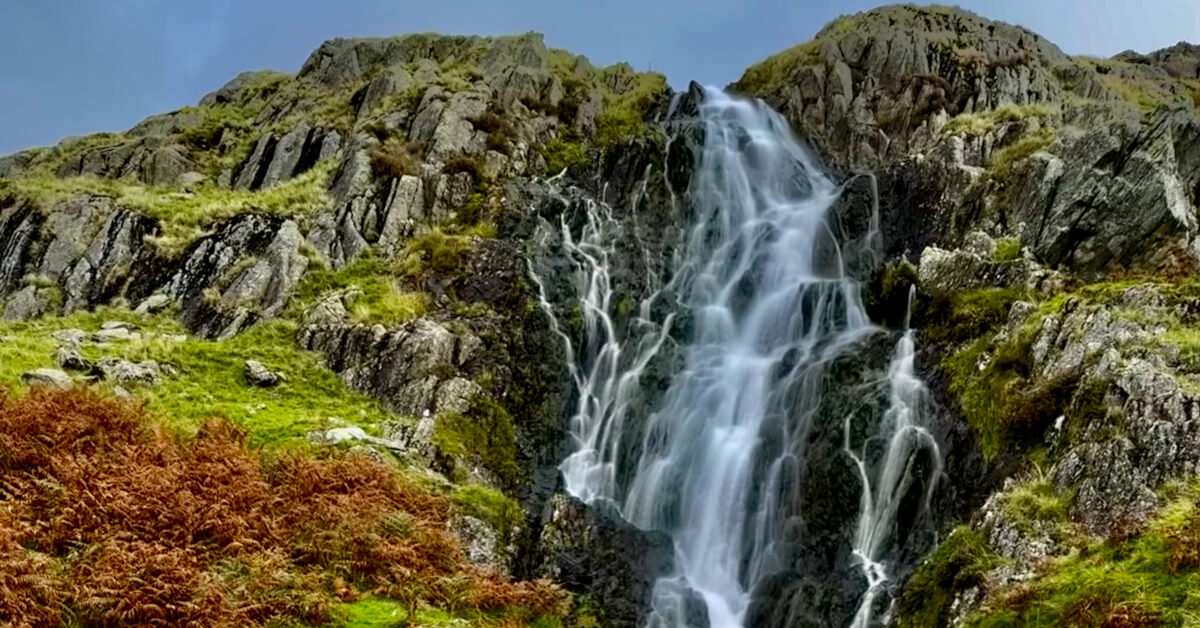
The path returns up onto the cliffs and I continue, eventually dropping down to the beach at Esson’s Gully. The beach runs beneath the cliffs, and at the far end a spectacular waterfall pours over the sheer headland onto the beach, like something from Jurassic Park.
Immediately after this point, steps take me back up on the cliffs and I pass by a couple of holiday villages — very quiet at this time of year — before heading back onto the beach. Here a sign points the way to Watchet, and I can see the harbour lighthouse ahead around the next headland.
However, before long I am climbing steps off the beach once more to take the clifftop route into the town, dropping in above the picturesque marina and passing by the Ancient Mariner statue.
I’d never visited the town before and it seems a lovely place. It’s a shame that I have to continue, as it would be a treat to spend a little more time here.
.jpg) Lots to see on the way to Minehead
Lots to see on the way to MineheadOut of the town, a steady climb up the road leads to the site of Daws Castle, an Iron Age hillfort long since disappeared, leaving a mere trace of what once stood here. Once more on the cliff path, the route takes me through a spiritual-seeming woodland before dropping down to Blue Anchor.
Here the path runs alongside the West Somerset Heritage Railway line, where a steam train huffs-and-chuffs past against the impressive backdrop of Dunster Castle on the edge of Exmoor.
The path separates the golf course from the sea and I am conscious of the prospect of low-flying golf balls accompanied by the cry of ‘Fore!’, but today their aim is true and I am undisturbed.
The other side of the course sees the path meander through sand dunes and into Minehead. I continue past the holiday centre and follow the promenade around towards the harbour. My previous visit here was to start the first leg of the South West Coast Path, and so I know I am making for the sculpture of hands clasping the map of that route. This time they will mark the end of my journey rather than the beginning.
.jpg) Looking back on the Somerset Coast Path
Looking back on the Somerset Coast PathAs I reflect on the previous five days of walking, I realise what a diverse route the Somerset Coast Path is.
It climbs from the busy seaside resort of Weston-super-Mare to the heights of Brean Down and sees a little of the history of this spectacular site.
It takes in the wide expanses of beach at Berrow Sands and Burnham, before embarking on a wonderfully peaceful journey inland to Bridgwater, accompanied by such a wide variety of birdlife alongside the River Parrett, both inland and back out to Steart Marshes. Hinkley Point stands large in the distance for much of the approach to this huge site, but it doesn’t detract from the experience; it is a fascinating place that is almost hidden from view despite its size once you are upon it.
The Jurassic Somerset coastline is evident in the eroding cliffs beyond here, as the route undulates on to Watchet and, finally, Minehead at the culmination of my walk. I am sad to leave this tranquil haven, but gratified to have had the chance to visit and walk its contrasting coastline and riversides.
Contours Holidays pride ourselves on our expert knowledge of the UK’s trails. We regularly set out to check our routes and directions and to make improvements on the holidays we offer. You can find several write-ups of staff expeditions in our Trail Diaries.
Interested in walking the Somerset Coast Path?
Contours Holidays offer three flexible self-guided walking itineraries along the Somerset Coast Path. Find your holiday here:
Senior Customer Services Advisor
The best fuel for mountain biking is cake.