Land's End to John o'Groats
Planning your walk from Land's End to John o'Groats is a big part of the undertaking. We suggest a few trails to help spirit you up the country through the best British scenery around.
Land's End to John o'Groats
https://www.contours.co.uk/lands-end-to-john-ogroats
Land’s End to John o’Groats is one of the toughest challenge walks in the UK, spanning over 870 miles if following only roads at an absolute pavement-pounding minimum. If you rightfully ditch the road to take the scenic route, expect to hike 1200 miles and more, spread over 2–3 months.
As the name Land’s End to John o’Groats suggests, this epic ramble stretches all the way from Land’s End at the southernmost tip of England to John o’Groats on Scotland’s northern coast. Those are the only required locations on this unusual walk, as there’s no set route to follow.
You’ll need to combine public footpaths and rights of way with established long-distance trails (and the occasional paved trek) to bring your journey to fruition. Part of the fun of walking from Land’s End to John o’Groats lies in the planning: which trails do you want to enjoy along the way?
LEJOG or JOGLE?
Those are the affectionate nicknames given to Land’s End to John o’Groats or its exact opposite: John o’Groats to Land’s End. You can attempt the challenge in either direction, shaping the way your walk develops: as a return to the built-up south, or an escape to remote expanses of the north.
We’ll talk about LEJOG in this article to keep things straightforward, but everything can easily be flipped around if you’re walking the other way.
There are plenty of great footpaths to choose from as you build your Land’s End to John o’Groats route, including a host of National Trails and other well-recognised long-distance walks. Contours Holidays offer a wide variety of them as self-guided walking holidays that you can link together.
Booking with us could help you cover a considerable portion of your overall mileage in a way that’s worry-free, with each accommodation pre-booked, daily luggage transfers all arranged, and our helpful office on hand 24/7 with help and advice.
You’ll still need to bridge a few gaps in your route between our trails, but we’re happy to offer suggestions to help fill those in. In fact, we list a few potential options below.

Plan With Our Map
Our interactive Holiday Location Map can help you identify some of the best long-distance trails to incorporate into your journey north.
Don’t forget that our holidays are flexible, so if a trail goes further than you need for LEJOG, tell us where you’d prefer to depart the trail and we can amend your itinerary accordingly.
As Land’s End to John o’Groats is such a flexible route, we don’t offer a dedicated itinerary to get you all the way from end to end. Plenty of our walking holidays can be used as foundational parts of your hike, however. Here’s just one combination of trails that, paired with cunning use of intermediary country lanes and footpaths, could greatly reduce the weight of planning for over a thousand miles out of the full 1200+.
Please note that some of these trails need to be booked in reverse to direct you from south to north. You can tell a reverse trail by the (R) in the title. Get in touch if you need to book one of these reverse holidays.
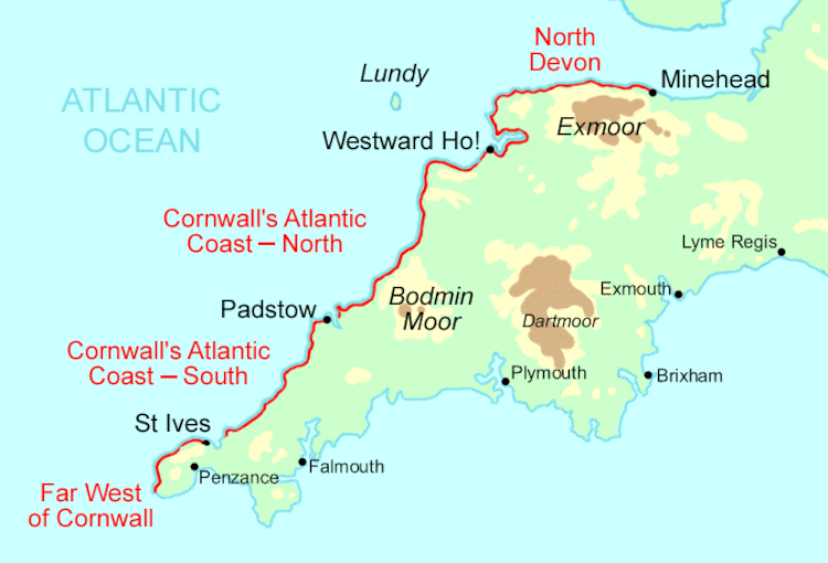
Distance: 236 miles
Start/End: Land’s End to Minehead
As England’s longest waymarked footpath, the South West Coast Path is epic in itself, clambering from sandy bays to clifftop heights as it curls around the pronounced south-west foot of England. This stretch from Land’s End to Minehead along the northern coast brings you a whopping 200+ miles towards your John o’Groats goal.
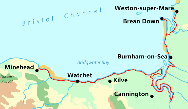
Distance: 66 miles
From/To: Minehead to Weston-super-Mare
Continuing along the coast from the South West Coast Path, the Somerset Coast Path offers a comparatively gentle, lower-level walk. The scenery here is no compromise, however, secretly hosting some brilliant fossil beaches, with plenty of welcoming seaside villages along the way.
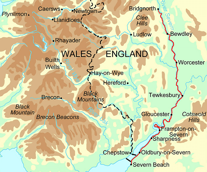
Distance: ~122 miles
From/To: Bristol to Ironbridge
From the Somerset Coast Path, find your way up the coast to Bristol, where the Severn Way begins. Walked in reverse, this riverside route starts at the mouth of the River Severn and winds between England and Wales in search of the river’s source, perched high above Hafren Forest — but for LEJOG you’ll only need the South Section. It could take you as far as Ironbridge, halfway up England.
Distance: 47 miles
From/To: Rocester to Castleton
We don’t offer any direct routes through the middle of England, though you could stitch together some combination of Offa’s Dyke Path and parts of the Welsh and English coast paths.
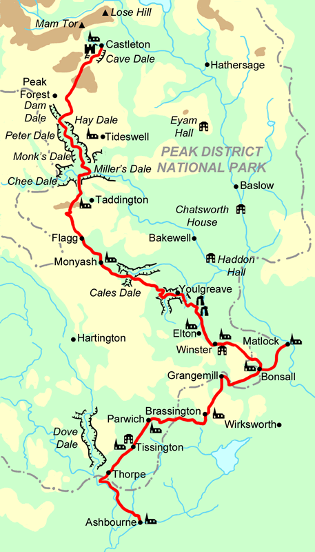
The most important thing, we think, is to reach and walk the Limestone Way. This trail explores rocky stretches of the Peak District that are geologically distinct from anywhere else in the country. What’s the point of walking Land’s End to John o’Groats if not to see the full variety of landscapes on our pretty island?
You can follow the Limestone Way up to Castleton and cross to Edale over the Great Ridge Walk.
Distance: 265 miles
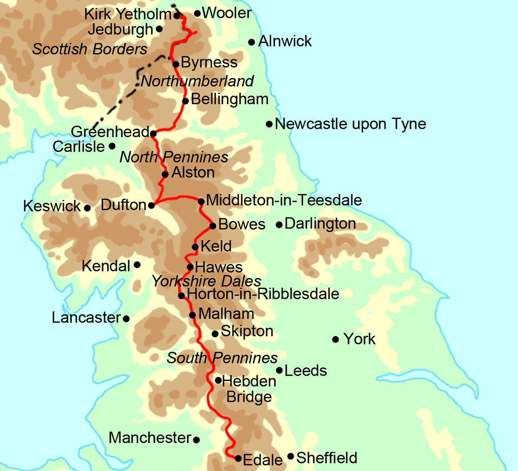
From/To: Edale to Kirk Yetholm
From Edale, England’s oldest National Trail will bring you all the way to the Scottish Borders, although not entirely without a fight: this challenging hike is well-known for its remoteness, exposure and elevation.
It’s well-worth the struggle, though, with plenty of walker-friendly pubs and hotels along the way, and some absolutely gobsmacking sights to discover out there in the wilderness.
Distance: ~37 miles
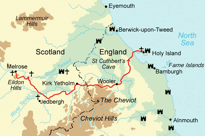
To/From: Kirk Yetholm to Holy Island
Split St Cuthbert’s Way down the middle and walk the eastern half to the stunning Northumbrian coast. The Scottish Borders prove impressively remote on this spiritual route, leading into great views in the fringes of the Cheviot Hills. You can cross the causeway to Holy Island when you reach the coast or turn more directly north and march onwards on the Forth to Farne Way.
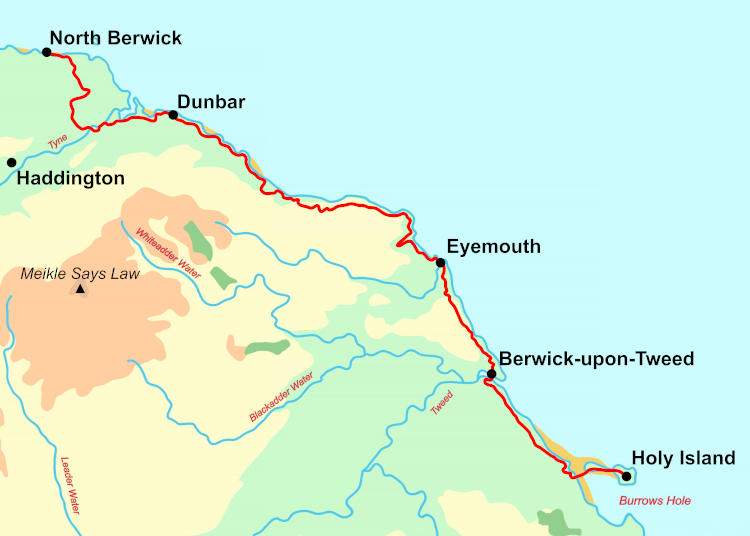
Distance: ~64 miles
From/To: Holy Island to Dunbar
The Forth to Farne Way follows a windswept coastline in the footsteps of medieval pilgrims, adding priories, churches and castles to your LEJOG adventure.
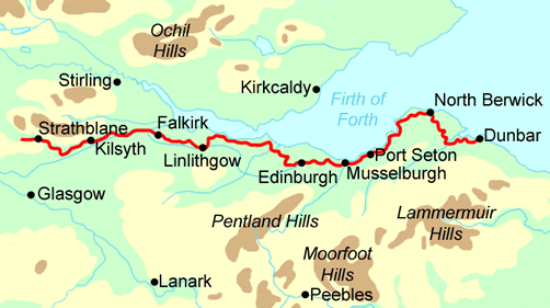
You have a choice of routes from Dunbar to North Berwick as this stretch is covered by both the Forth to Farne Way and the John Muir Way. The trails are quite similar in terrain and mileage, so you can decide pretty much on the day!
Distance: ~107 miles
To/From: Dunbar to Strathblane
In the spirit of John Muir, who felt everyone should have access to the countryside, the John Muir Way is a level, approachable trail that promises an easy walk with lots to see, including the famous Kelpie statues and Edinburgh itself.
This route brings you across Scotland to meet the West Highland Way, an iconic northward trek. The two trails cross over between Strathblane and Carbeth, so you can make the switch there.
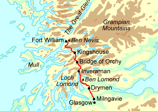
Distance: ~90 miles
From/To: Drymen to Fort William
Perhaps the best-known of Scotland’s Great Trails, the West Highland Way tours the banks of enormous lochs and explores the rugged peaks of the Scottish Highlands. Pockets of civilisation feel few and far between out here, but you’re sure to meet plenty of other walkers en route, amping up the sense of adventure and comradery in your end-to-end ramble.
Book your West Highland Way walk well in advance, as accommodation on this trail is notoriously hard to secure.
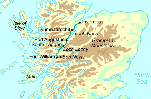
Distance: 77 miles
From/To: Fort William to Inverness
Inverness is as far north as a Contours Holiday will bring you, but what a send off the Great Glen Way provides. This Great Trail follows the line of the Caledonian Canal, taking in stunning views of enormous lochs and the peaks of the Scottish Highlands. The walk brings you all the way up to the North Sea at Inverness, with just the Highlands to cross to reach your destination at John o'Groats.
 The above is just one of many meandering ways to traverse this country from south to north. With a few straightforward tweaks you can fully change the character of several sections, demonstrating just how different LEJOG routes can be from one another:
Between the trails Contours provide as established walking holidays, there are a host of smaller, local walks that provide great connective material to fill in the blanks on your LEJOG route. Here are just a few of these excellent options.
Linking: the Severn Way with the Limestone Way.
The Monarch’s Way could replace the Severn Way entirely, both trails passing through Bristol after the Somerset Coast Path. Otherwise, the Severn Way almost touches the Monarch’s Way just east of Ironbridge, and from there it’s an enjoyable ramble west to meet the Staffordshire Way near Brewood. This winding trail heads north through Cannock Chase and the Trent Valley to Rocester and the head of the Limestone Way.
Linking: the Cumbria Way or Hadrian’s Wall Path with the West Highland Way
The North-West section of the England Coast Path bridges the way from Carlisle to Gretna, which puts you within 12 miles of Annan and the Annandale Way. You’ll need to figure out how best to skirt the Solway Firth to join the route, but once you’re on it, the Annandale Way will bring you all the way to Moffat.
From here, the intensely remote Southern Upland Way becomes an option. This coast-to-coast trail will bring you as far east as you need: head all the way to the trail’s end at Cockburnspath to join the Forth to Farne Way up Scotland’s far coast, or depart the trail at Wanlockhead to walk the Clyde Walkway from New Lanakar to Glasgow. The Kelvin Walkway connects Glasgow with Milngavie and the West Highland Way.
Linking: Land’s End with the Anglo-Scottish border
With the launch of the complete England Coast Path just this year, the entire coast of England is now walkable — although we haven’t added it all to our range of walking holidays just yet. Still, if you’re a big fan of the seaside, your LEJOG route could keep entirely to the coast. (Don’t forget the Wales Coast Path, too, if you want to add an even sillier amount of coastal mileage to your journey.)

A big part of Land’s End to John o’Groats is picking out a route that suits you personally. We look forward to seeing what creative treks you put together yourself.
Be sure to get in touch if you want Contours to book even a short stretch of your journey. We’d love to support the adventure of a lifetime!


